16 days of pure trekking. Starting in 1800 metres in T-shirt and shorts, culminating in 4800 metres in the warmest gear you can imagine and finishing totally wet because of the monsoon season. Accomodation provided for us varied from Hindu houses to Tibetan Buddhist mountain houses. We passed a village inhabited solely by Tibetan refugees and ended up in area populated by small Limbu community. We used approximately 30 chlorine water purification tablets for obtaining clean drinking water. We ate dozens dalbats (traditional Nepali meals) and drank litres of tea. We saw rhododendron forests and yak caravanas almost daily. Nothing serious happened to us during the trek, torn cap and whole body aching doesn´t count. All this paradise costs circa 135 per person.
This is how we can simply describe the biggest trek I have ever made in my life. But we can explain in a little more in deep of course 🙂 Plan for some Himalayan trekking appeared in our heads probably right after we got both chosen for European volunteering programe in Nepal. We knew that we do our best to go trekking during our stay in Nepal. We arrived to Nepal at the beginning of February and started treking in the middle of May. Firstly, I thought that we could get every necessary information concerning trekking in Himalayas during our volunteering period as we would be constantly surrounded by locals. I knew before after arrival to Nepal that we will be located away from Himalays, in the térai lowlands but I kept reassuring myself that those local people must know more than us. Surprisingly, it was a wrong thinking. Himalayas are really far far away from our southern jungle district Jhapa. I don´t mean now the geographical distance. Our local friends didn´t visit Himalays nor trek there so I had to try other ways how to get information needed.
Don´t plan trekking from Nepali lowlands
So I stopped asking my local friends and I started googling. Both of us decided to do trekking around Kanchenjunga (8586 metres), which is third highest peak. It is a border peak of Nepal and Indian state Sikkim and it´s a closest eight thousand peak from our village. The most frequented trek in Himalayas is probably Annapurna (10th highest peak). Information about Annapurna trekking were really detailed and abundant. For instance, CouchSurfing forums dedicated to Nepali trekking were full of trekking companion seekers adding posts daily for Annapurna treks. Trekking around Kanchenjunga was obviously not that spread and popular and I didn´t find almost anything suitable there. Our Slovak friend, traveler and writer Michal Knitl described his own experiences with Kanchenjunga trek from few years ago in his latest book so we got some useful advices. We accidentally met with one tourist guide in Kathmandu and spoke about the trek. He assured us it´s a good choice, little unusual, but definitely cheaper than Annapurna. He recommended us to try to bargain as much as possible. Actually, the prices over there were comparable with the Annapurna´s prices…We only realised it after the trek when we compared prices with other trekkers. Most probably it´s not that expensive in Annapurna anymore, because it´s a big concurence over there. When trekking Kanchenjunga, we rarely saw more than one hotel-lodge in one village.
You can´t forget the map and a trekking permit!
Few days before the trek, we went to Kathmandu to extend our visa to the Immigration Office. Along the way, we also arranged the trekking permit which costs 20 USD. During trekking we got to know that the official spring trekking season already finished (according to the various guidebooks it should lasts until the end of May but locals said it´s gone by the end of April) and this was most probably the main reason why we never encountered any check-points which were marked on the map. The only time when someone needed a permit from us was in Ghunsa village and it was a hotel owner.
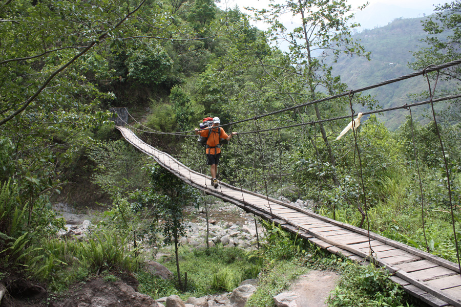
Back in Kathmandu, we also bought a detailed trekking map with approximate times. In this place, we have to say that either we were super slow trekkers or those times in a map were just super wrong. Most of the time we needed to double the time indicated in the map to get our hiking time. We hiked 10 hours during first days. Then it got better and we hiked for 6 or 7 hours a day. These are all brutto times so consider please our frequent breaks for drinking, snacks and ample time for observing and photographing the beautiful nature around us.
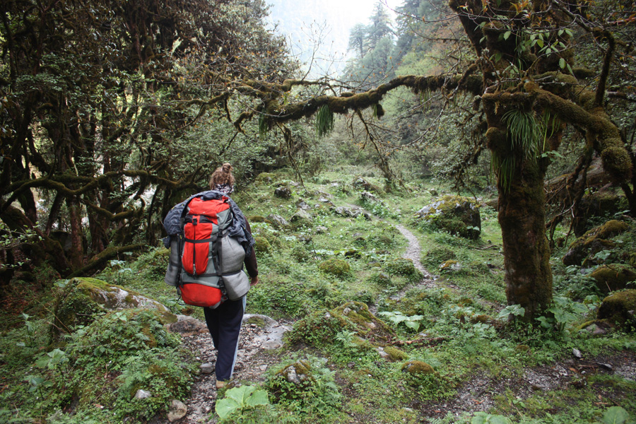
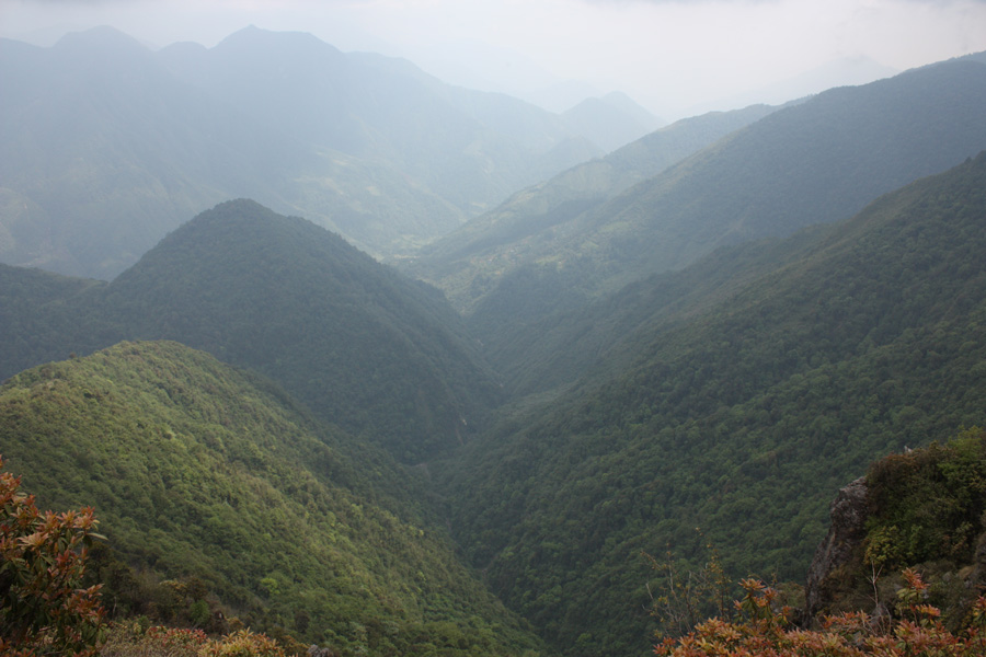
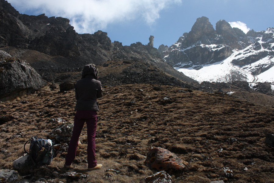
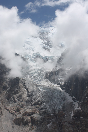
First and last days of trekking (low altitudes) went through Himalayan jungle. We were still in Hindu area so we kept seeing typical Hindu temples and Hindu people in traditional dresses as we know them from our small village in the lowlands. On our third day of trekking, we finally entered Buddhist area and for the night, we stayed in a typical Buddhist house. It was at around 1500 metres above the sea level. The snowy mountains of Himalayas were on the sight only at our 6th day when we stayed for two days in super nice mountain village Ghunsa populated solely by Tibetan Buddhists. It was already in 3500 metres and we had a rest day there.
Trekking equipment doesn´t need to be super professional
We wanted to go trekking to the Himalayas but we didn´t wanna spend a fortune on a mountain gear nor have a heavy bags so we didn´t hire a guide or porter and we didn´t take tent neither portable stove or prepared food to cook. We knew before there would be accommodation and food facilities along the way. We took sleeping bags (not a good quality, but we were able to use extra blankets provided by hotel owners that is why we didn´t freeze 🙂 and we also put on all warm clothes we had so we survived).
The prices over there were way higher than we expected. We understand Himalayas are super touristy area, but Kanchenjunga is one of the least visited trekking routes, quite far away from central Nepal. For example, the prices of regular meals were sometimes 10 times higher than in lowlands. If we arrive for trekking directly from Slovakia we wouldn´t complain that much about the mountainous high prices but as we have been in Nepal for already five months, we really saw enormous difference. Example: we drink regular Nepali black tea for 10 rupees here in the south. But the price for one cup of black tea in 4500 metres was 100 rupees. Dalbat (traditional rice meal) costs around 100-150 rupees here. The regular price for dalbat up in the Himalayas was 500 rupees and the most expensive one costs 700 rupees. After trekking, when we spoke with our lowlands friends about those high prices, they didn´t believe us.
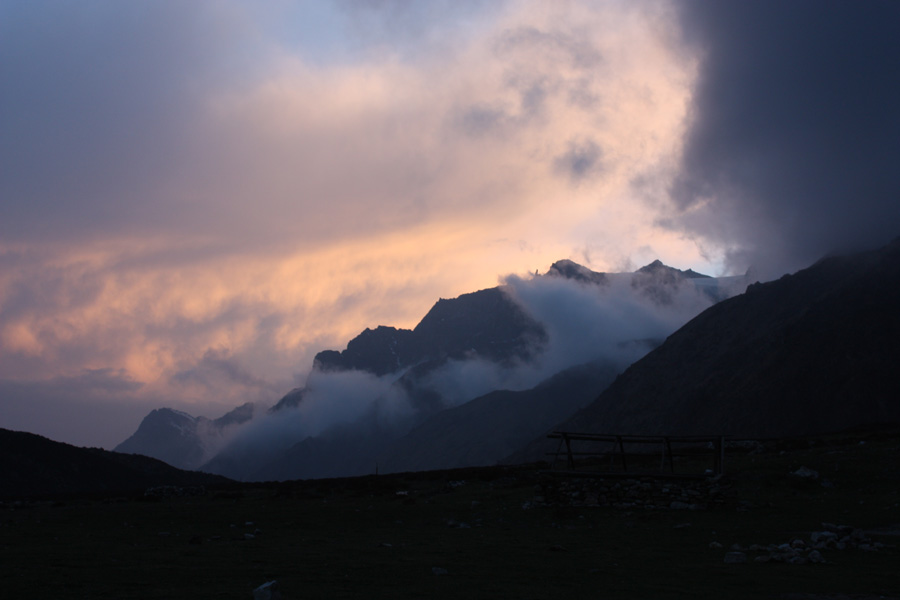
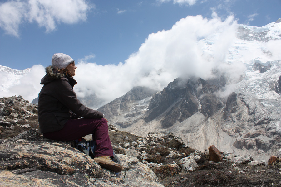
- Sunset scenery in 4500m.
Little Tibet in Nepal
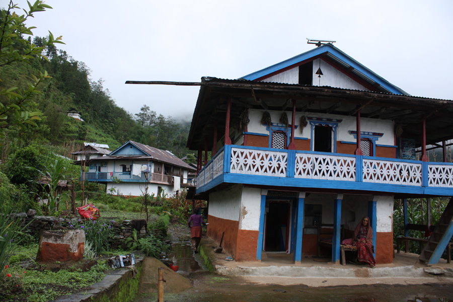
We didn´t expect Hindu people up in the mountains and we were ready for some Buddhists. Buddhists colourful praying flags really decorated houses from circa 1500 m. altitude. But we didn´t know we would visit whole Tibetan villages. The photo of Dalajlama was in almost every house and people were speaking Tibetan language among each other. And we thought we can use our basic Nepali in order to impress our hosts 😀 We tried Tibetan salt tea made of yak butter, tea, salt, milk and spices. It doesn´t taste at all as a tea but we liked that hot drink 🙂 Tibetan bread is also very tasty 🙂 All mountain villages we passed on the way were mostly populated by Tibetan-Nepalis (Nepali citizens whose ancestors came from Tibet many many years ago) but one whole village called Phale (3140 metres) was inhabited by true Tibetan refugees. We got to know this only later but when passing this village we noticed one local wearing a cap with writing Free Tibet. So we politely asked to take a picture of him 🙂 Traditional Tibetan Buddhist house consists of one big room where they serve food, sleep and cook. The stove is located inside the house and the ventilation is ensured by holes in the roof, windows and doors.
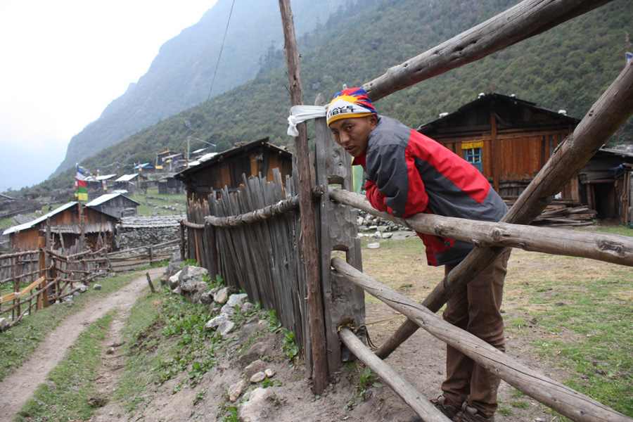
Phale village inhabited by Tibetan refugees and the guy with Free Tibet writing on his cap
Foreign trekkers, sherpas, climbers and Slovak stickers
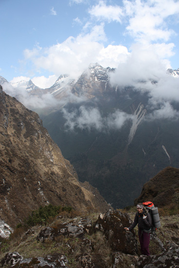
During our whole 2-week trek, we met less than 10 international trekkers. We heard that this amount of trekkers is encountered in an hour when hiking Annapurna trek. We met local sherpas daily. They are quite young guys (around twenty), they usually carry 40 kilograms on their backs, they speak quite good English because many of them work as tourist guides too and they could very easily guess from our look and English accent that we came from Eastern Europe. They heard about Slovakia and Slovak trekkers. It was such a difference comparing to the people from lowlands. These sherpas go very fast and normally can make a distance three times shorter than a regular trekker. So that is why when we asked them for an average time needed to reach a certain point, we have to triple the time. At the beginning, we didn´t know about this magical alghoritm so we were really dissapointed and didn´t understand why those villages are so remote. After some time, we realized that 20 minutes for sherpas is exactly one hour for us and we were finally fine.
Among international trekkers we met on the way, we spoke the most with two Israeli guys with whom we accidentaly spent a night in a pass shelter in 4100 metres. Those two guys didn´t trek on Saturday because of shabat, in the evenings they read a book dedicated to 1973 Israeli-Arab war and they both were hikig so fast so we couldn´t go together. On the other way, two American girls from Colorado were so slow and their sherpa was evidently very bored when waiting for them all the time. He seemed like it was a very slow promenade in the moutains. We also met one Bulgarian climber from Sofia who was just coming back from the real top of Kanchenjunga! For unknown reason, he didn´t use helicopter to take him to lower locations after the climbing but he went all the way down as a regular trekker. There was a deadly accident in his expedition when three climbers died. Young unexperienced female climber from India fell down from with her two Nepali sherpas who were securing her. Rest in peace.
We have been seeing yaks, which are huge mountain cows several times a day. They were carrying heavy stuff on their backs but they were moving quite easily! It was so impressive. Yak caravanas were aware of the trekkers preference on the path so when we encountered those huge animals inside the steep forest, they patiently waited until we moved. Yak´s body is perfectly adjusted to the harsh Himalayan climate. Possession of two more ribs and three times more red blood cells than cow provide easier breathing in high altitudes. There is also a downside, when the yak descends below 3000 metres, his immunity system is affected and inefficient.
Every mountain hotel, restaurant or shelter wall in Kanchenjunga was full of commercial stickers advertising trekking agencies attracting Western trekkers. When observing these stickers, we found very interesting one. It was a sticker from famous reputable Slovak company Matador which is producing car tyres! We saw these stickers on four different places in Amjilosa, Phale, Yamphudin a Kebang. When we asked about the origin of the stickers, no one from owners remembered the trekkers or expedition.
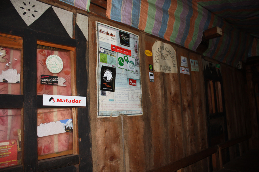
- Matador stickers all along the trek, Slovaks are everywhere 🙂
Monsoon arriving to the mountains
Now, I would like to describe probably our hardest day. On the 9th day, we hiked totally 13 hours, started at 5am with hyper fast Israeli guys (frankly speaking, if they don´t encourage us to wake up that early, we would sleep until 7am or so and start trekking around 8am as we did every day). Thanks to the early start, we had the chance to see wonderful sunrise in 4000 metres, we passed three snowy mountain passes (the highest elevated was in 4700 metres) and then we had a really hard steep descent to the 3500 metres. During descending it started to rain lightly so we didn´t really pay attention. Suddenly it turned into really heavy monsoon rain. The bad thing was that we were on the rock cliff. It was definitely not more than 2 hours from our final destination but we had to stop for a while and decide what to do next. After half an hour, completely wet, without any sign of the end of rain coming soon, we decided to slowly continue downwards. Fortunately, there was a small tea house on the way where we changed our clothes into the less wet ones and had a warm tea (yes, we know there are raincoats and water-proof covers for bags but don´t ask me please why we didn´t take those things).
From the cozy tea house to our village with hotel it was only 1 or 2 hours up the river according to the people from tea house. I think it is not necessary to say that it took us almost 3 hours, we were all wet, super tired after the longest hike and we just needed to fall in the bed and sleep. When we finally reached the village with two mountain lodges, nothing more, there was unusual rush, too much people and little mess. It was an expedition of climbers coming back from the Kanchenjunga top. They were escorted to the lower altitudes by the helicopter the following morning. When we asked about any free place for a night in first hotel, they didn´t even look at us and just said it´s fully packed. So we went and asked in second hotel which was again full without any free places. In that moment, I literally mentally died. I sat down on the floor next to the hotel entrance and was unable to move. The only thing I didn´t wanna know was that they didn´t have a place for us. Peter was fortunately more responsible and started asking to any seriously looking locals about the possibility to sleep anywhere. Finally we ended up sleeping in something like a storage. Our all wet clothes were hanging from the ceiling and drying and we slept in those few clothes which were not that wet. From that early morning, the expedition guys were constantly coming to our storage and taking out their gear. After 8am, there was finally a quiet because all climbers were already taken by the helicopter.
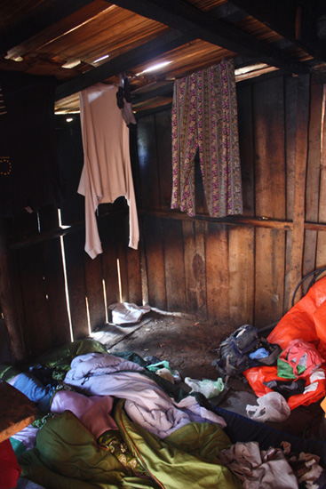
- Our sleeping place in a cold storage in 3800 metres
Trekking route:
1. Taplejung (1820m) – Suketar (2420m) – Phurumbu (1542m)
2. Phurumbu (1542m) – Chiruwa (1272m)
3. Chiruwa (1272m) – Taplethok (1380m) – Sukathum (1576m)
4. Sukathum (1576m) – Amjilosa (2308m)
5. Amjilosa (2308m) – Gyabla (2730m)
6. Gyabla (2730m) – Phale (3140m) – Ghunsa (3595m)
7. aclimatization day in Ghunsa (3595m)
8. Ghunsa (3595m) – Selele Pass (4290m)
9. Selele Pass (4290m) – Mirgin La Pass (4480m) – Sinelapche Pass (4646m) – Cheram (3870m)
10. Cheram (3870m) – Ramche (4580m)
11. Ramche (4580m) – Oktang (4730m) – Ramche (4580m) – Cheram (3870m)
12. Cheram (3870m) – Tortong (2995m)
13. Tortong (2995m) – Lassiya Pass (3600m) – Yamphudin (2080m)
14. Yamphudin (2080m) – Kebang (1910m)
15. Kebang (1910m) – almost Khandeme (I have no idea what´s the altitude, it was not on the map…)
16. almost Khandeme – Khandeme (I have no idea what´s the altitude, it was not on the map…

We would be very glad to get your comment